
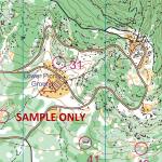
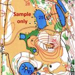
Brimbank Park Orienteering Map with permanent controls
$5.00
Full-colour A4 orienteering map of Brimbank Park, Keilor (north west of Melbourne) – includes permanent control marker locations, legend, navigational features and map information.
Use the permanent markers to choose your own course(s) or conduct a “scatter-O” event.
Full-colour A4 orienteering map of Brimbank Park with permanent control points marked. Includes navigational features such as contours, paths, creeks, buildings, thick bush, clearings etc.
Suitable for orienteering, hiking or bike riding.
Brimbank Park is located on Keilor Park Drive, Keilor East, not far from the off-ramp at the intersection of Calder Freeway and Western Ring Road.
Map & Course Information:
- Open parkland
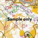
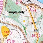
- 31 controls on posts with punches
- Scale: 1:5,000
- Contour Interval: 5 metres
- Full colour
- A4 size
- Comes with control punch card
Please note that you will be sent a printed copy of the map, not an electronic copy.
**Select the “Map Only” postage option on checkout if you are only purchasing maps**
Brand
Tuckonie Orienteers
Related products
-
You Yangs Branding Yard Orienteering Map with permanent controls
$5.00 Add to cart -
Westerfolds Park Orienteering Map with permanent control locations
$5.00 Add to cart -
You Yangs Kurrajong Area Orienteering Map with permanent control locations
$5.00 Add to cart -
Cardinia Reservoir Orienteering Map with permanent control locations
$5.00 Add to cart -
Darebin Parklands Orienteering Map with permanent control locations
$5.00 Add to cart
Reviews
There are no reviews yet.